
Een analyse naar wonen in Nederland
WoneNederland
Met de opgave van het zorgvuldig en snel realiseren van één miljoen woningen in het achterhoofd, heeft Vereniging Deltametropool een project opgezet met als doel inzicht te verkrijgen in de huidige woningbouwplannen op nationaal niveau en deze vanuit ruimtelijk en sociaal perspectief te analyseren.
Met deze analyse, kunnen goede en verbeter punten worden aangedragen en kunnen thema’s worden benoemd die extra aandacht/uitwerking nodig hebben. Dit creëert overzicht in de nationale woningbouwopgave en zorgt ervoor dat deze efficiënter en met hogere kwaliteit uitgevoerd kan worden. Samenhangend met deze analyse, wordt onderzocht welke thema’s uit andere (ruimtelijke) domeinen in de toekomst meer/minder belangrijk zullen worden. Ook de uitkomsten van dit onderzoek zullen gerelateerd worden aan de huidige woningbouwplannen en uitkomsten hieruit kunnen ertoe leiden dat deze meer toekomstbestendig worden. Concluderend uit deze analyses, kunnen nieuwe richtlijnen voor het plannen van woningbouw gemaakt worden.

Het project is opgebouwd uit drie hoofddelen die deels parallel uitgevoerd worden. Ten eerste wordt de huidige situatie op gemeenteniveau in kaart gebracht. Hiervoor wordt een breed spectrum aan thema’s rondom ‘wonen’ geanalyseerd, variërend van gezondheids- en criminaliteitscijfers tot bevolkingstrends en woontevredenheidscijfers. Met deze analyse wordt inzicht verkregen in de huidige situatie rondom ‘wonen’ in Nederland en wordt vastgesteld waar knelpunten liggen. Ten tweede worden woningbouwplannen in kaart gebracht. Bij wijze van test is dat als eerste voor de Provincie Zuid-Holland gedaan, maar het doel is om dit voor heel Nederland te doen. Hierbij wordt ook onderscheid gemaakt tussen korte en lange termijn plannen. Elk van deze plannen worden langs een aantal locatie specifieke thema’s geanalyseerd, zoals bereikbaarheid en nabijheid van voorzieningen. Ten derde worden ze in relatie gebracht met uitkomsten van de analyse van de huidige situatie. Daarnaast wordt er ook gekeken naar ‘thematrends’, kortom welke thema’s in de toekomst waarschijnlijk meer of minder belangrijk worden. Op basis hiervan en van de hierboven beschreven analyses kunnen goede en verbeterpunten worden aangewezen in het woningbouwbeleid. Ook komen kansrijke locaties in beeld.
WonenZuid-Holland
Development Patterns and Landuse
As part of the ongoing research project regarding the province of Zuid Holland’s housing plans, the Deltametropolis Association aspires to both forecast and reflect upon the nature of housing development within the province as it aspires to provide new 235,000 homes by the end of the decade. This article will explore the nature of past development and growth, understanding the trends and patterns present that drove it and how future trends differ from those of the past.
The population of Zuid Holland grew significantly following the conclusion of World War 2. In order to accommodate this growth the country and province had to meet the subsequent housing demand. Initially this was achieved by expanding existing residential centers outwards into unresided land, predominantly agricultural green space.
This development saw the built footprint of the province almost grow significantly in the 76 years postwar with the land occupied by residential development in the province growing from 10,749 hectares in 1945 to 35,465 hectares in 2015. This development manifested itself in two major ways . Firstly through the expansion of already existing urban centers, notably Rotterdam and The Hague which grew out into neighboring municipalities and secondly through the establishment of new medium sized settlements such as Zoetermeer.
The map below created with the CBS 100m vierkant exhibits the spatial distribution of this growth through these decades.
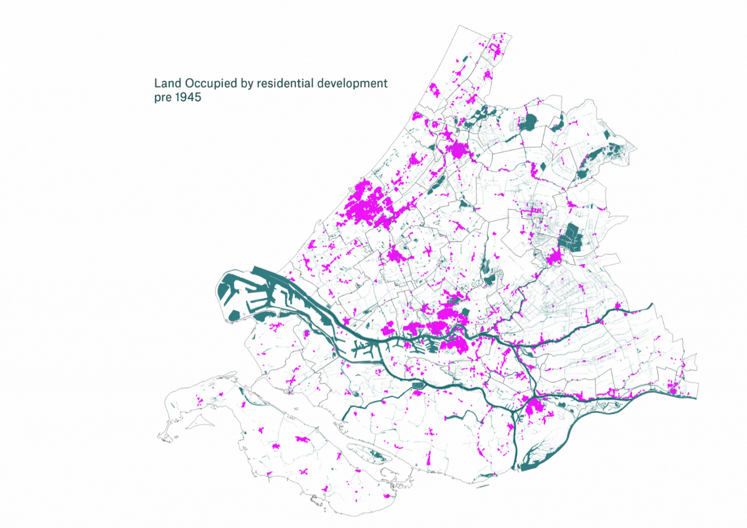 Growth of Zuid Holland residential development in ha.
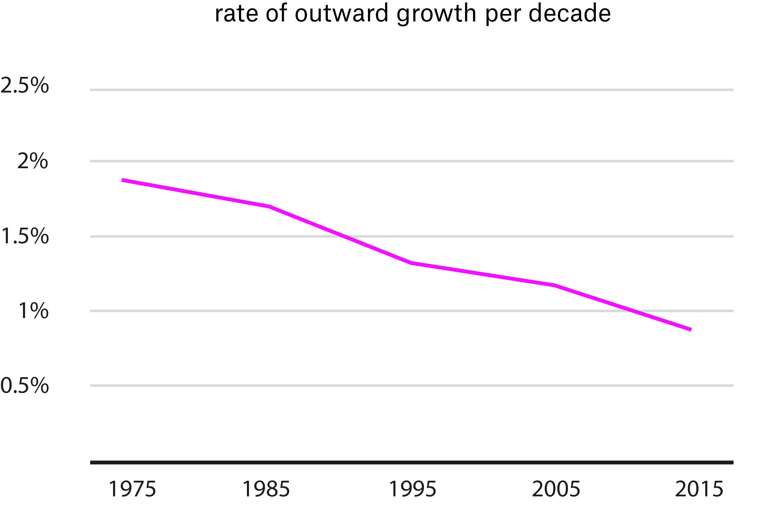
These developments have historically satisfied a growing population but have come at the cost of land. These tradeoffs however are becoming increasingly costly with the growth patterns commonly seen in the mid 20th century appearing increasingly unsustainable in the early 21st century.
The tradeoff of surrounding agricultural land for housing development has become increasingly costly. This is in parts due to the increasing scarcity of the land caused by past development and the growing importance of its role in sustaining the populations of these urban populations. Furthermore, there are larger environmental and social concerns that arise from these growth patterns that suggest there is diminishing benefits to developing this land.
These changing dynamics have culminated in a move away from sprawl in recent decades and this is evidenced in the recent growth patterns with the rate of outward development reducing consistently from 1975 onwards, seen in the graph below. Albeit this is caveated by a similar decline in housing development during this same period.
 rate of ou.
In order to understand the rate of expansion into the surrounding terrains the 500m vierkant provides a better reference point. Using this metric to define existing residential terrains shows that only 26 of 727 new developments being constructed in the coming years are taking place outside of existing residential terrains. This analysis does not suggest that developments are greenfield or brownfield but instead shows that development is not taking place within terrains that have already been developed. This suggests that the downward trend in outward expansion is likely to continue into the future.
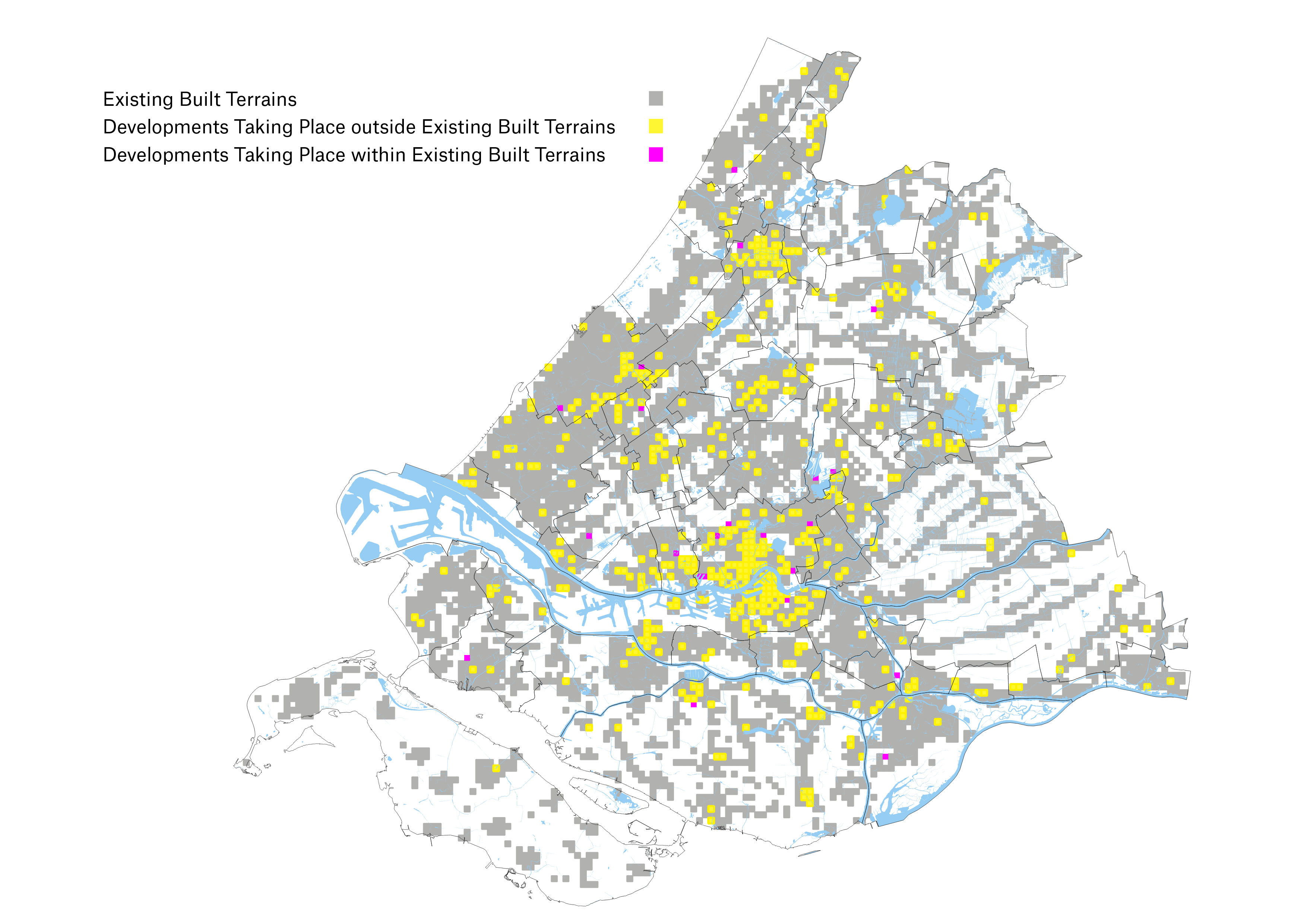 Built Nature of 500m x 500m squares.
There is a growing issue of space in housing development within Zuid Holland as the sprawling practices of the past become increasingly untenable owing to rising costs in developing in undeveloped land. As a result space for development appears to be in short supply this in turn creates both a desire and need to find and invent space within already developed areas.
The means of finding space within existing territories varies from municipality to municipality. In municipalities with smaller lower density populations such as Barendrecht this space does not necessarily need to be invented. Instead the municipality can rely on infill developments within existing settlements.
In more populous municipalities where there is a greater shortage of undeveloped land it is not possible to meet current housing demand with just infill development. Instead municipalities are tasked with inventing space. In analyzing the previous land use of the provinces upcoming developments and understanding can be gained regarding the patterns and dynamics of future growth.

A common strategy employed by municipalities in order to create space has been to reshuffle the locations of public services. Schools, fire stations, recreational facilities and churches frequently being either merged or moved in order to make way for new developments with 57 developments taking place on land previously occupied by schools, 21 on land previously used for recreational purpose (often tennis courts, football pitches and swimming pools) and 5 developments taking place in locations previously occupied by fire stations.
Reshuffling public services may impact the provision of said services and as a result there is a potential tradeoff in the public benefit offered by these services and the public benefit offered by the increased housing stock. This means the tradeoff has the potential to be rather costly for the public albeit these reshufflings and trades differ on a case by case basis.
A similar dynamic exists for industrial terrains although they offer less in terms of public benefit and more in terms of economic benefit. In certain instances notably in the Binckhorst in The Hague it has been deemed that this is a worthwhile trade.
These practices pose an interesting question on land valuation and public benefit, suggesting the existing need for greater housing access is of greater public and economic benefit than that of the services they have replaced. This may mark a shift in land value dynamics and dispute long held philosophies such as the bid rents model as residential development begins to take on greater value than economic development in the forms of retail, office development and industrial development.
 Distribution of previous land uses across upcoming developments within the province.
Less costly means of generating space for residential development came via redeveloping offices and automobile related infrastructure such as car parks and garages. Redeveloping offices appears to be a relatively inexpensive means of generating new sites as in a lot of cases the building can largely be preserved. Both cases cost little in terms of general public benefit and in the case of automobile related infrastructure the loss of benefit can be totally nullified by moving said infrastructure underground. If the debate around space is to become more intense a shift away from fossil fuel powered cars may arise, electrical vehicles requires significantly less land intensive infrastructure to refuel and alternatives to cars save the space otherwise occupied by parking and storage.
The timing of this study largely comes before the effects of the covid 19 pandemic and WFH are seen in the built environment. Another iteration of this study in the future may find a further increase in office to residential conversions as result of these trends.
A significant contrast in development patterns was seen in the number of existing residential developments that were being upscaled. With the exception of Rotterdam this was a rather infrequent prior landuse however and would generally come with the caveat of the existing stock being out of date. Of the total 176 developments taking place on sites already occupied by residential development, 129 were taking place within Rotterdam. This disproportionately high rate is due to the density of population and development in the city and the lack of undeveloped space in which to develope. Here the tradeoff made when upscaling residential development makes sense.
Upscaling residential development in other contexts appears to be a tradeoff that did not make sense, likely owing to the high cost and complexity of acquiring said sites and the lower potential for densification when compared to a major urban center such as Rotterdam. The complexity of redeveloping existing residential development is to be considered when developing new residential developments as decisions in these developments appears to be generally longer lasting than that of other land uses.
The increasing demand for housing increases the pressure on municipalities to find space. With growing consensus that outward expansion is not an appropriate means of finding this space municipalities are forced to look inwards, evaluate instances where space is underutilized and determine whether or not the tradeoff in developing this land is worthwhile. The gains and losses of these tradeoffs will prove to be a major planning consideration going forward.